ExifTool Version Number :
12.50
File Modification Date/Time :
2025:10:22 01:43:48+00:00
File Access Date/Time :
2025:10:22 01:43:48+00:00
File Inode Change Date/Time :
2025:10:22 01:43:48+00:00
File Permissions :
prw-------
File Type Extension :
jpg
Current IPTC Digest :
9759cec239130c7a6834f9ae9c605f20
Application Record Version :
0
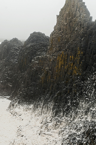
Caption-Abstract :
(March 13th 2012) - ÒMany residents along the coastline of Oregon awoke Tuesday morning to no power, downed trees, closed roads and as much as 8? of snow in a rare one-two punch. This storm will likely go down in the record books as one of the largest coastal snowstorms in the month of March ever recorded at some locations. Records date back to the late 1800?s along the Oregon coast. The last coastal snowstorm of this size in the month of March was in 1951 when between 4? and 8? inches of snow fell. What is even more rare about this storm is the fact that within 12 hours bewildered coastal residents went from 50 degrees with hurricane force wind gusts to 32 degrees and 6? of snow. All of this taking place just a week before the official start of spring.Ó ÒA strong Pacific storm raced ashore Monday morning bringing wind gusts to nearly 90 mph along the Oregon coast line. By sunset Monday, near record setting snows were falling along nearly the entire coastline of Oregon including the the shoreline beaches. Areas that were hit especially hard included Pacific City, Tillamook, Lincoln City, Newport and Florence, Oregon. This area spans about 100 miles. Hwy 101 near Cape Foulweather (just north of Newport, OR) was closed in both directions due to downed trees and stranded cars as snow fell on freshly fallen timber overnight. Here is a look at the snow totals as of Tuesday morning.Ó Special thanks to the Portland office of the National Weather Service reports this storm carried winds of 80 mph, with torrential rain and then later, snow and downed powerlines down the coast
Keywords :
storm, Oregon, Seal Beach, wave, foam, froth, violent, March 12, 2012, tide, rock, coastal, element
Copyright Notice :
Carol How
IPTC Digest :
9759cec239130c7a6834f9ae9c605f20
Displayed Units X :
inches
Displayed Units Y :
inches
Slices Group Name :
_CAH7606 S
Photoshop Thumbnail :
(Binary data 6214 bytes, use -b option to extract)
Has Real Merged Data :
Yes
Writer Name :
Adobe Photoshop
Reader Name :
Adobe Photoshop CS4
Photoshop Format :
Standard
Exif Byte Order :
Little-endian (Intel, II)
Image Description :
(March 13th 2012) - “Many residents along the coastline of Oregon awoke Tuesday morning to no power, downed trees, closed roads and as much as 8″ of snow in a rare one-two punch. This storm will likely go down in the record books as one of the largest coastal snowstorms in the month of March ever recorded at some locations. Records date back to the late 1800′s along the Oregon coast. The last coastal snowstorm of this size in the month of March was in 1951 when between 4″ and 8″ inches of snow fell. What is even more rare about this storm is the fact that within 12 hours bewildered coastal residents went from 50 degrees with hurricane force wind gusts to 32 degrees and 6″ of snow. All of this taking place just a week before the official start of spring.” “A strong Pacific storm raced ashore Monday morning bringing wind gusts to nearly 90 mph along the Oregon coast line. By sunset Monday, near record setting snows were falling along nearly the entire coastline of Oregon including the the shoreline beaches. Areas that were hit especially hard included Pacific City, Tillamook, Lincoln City, Newport and Florence, Oregon. This area spans about 100 miles. Hwy 101 near Cape Foulweather (just north of Newport, OR) was closed in both directions due to downed trees and stranded cars as snow fell on freshly fallen timber overnight. Here is a look at the snow totals as of Tuesday morning.” Special thanks to the Portland office of the National Weather Service reports this storm carried winds of 80 mph, with torrential rain and then later, snow and downed powerlines down the coast
Camera Model Name :
NIKON D300S
Orientation :
Horizontal (normal)
Software :
Adobe Photoshop CS4 Macintosh
Modify Date :
2012:03:24 00:16:31
Exposure Program :
Aperture-priority AE
Date/Time Original :
2012:03:14 12:33:14
Create Date :
2012:03:14 12:33:14
Shutter Speed Value :
1/320
Exposure Compensation :
0
Metering Mode :
Multi-segment
User Comment :
COPYRIGHT,CAROL HOW [all rights res]
Sub Sec Time Original :
89
Sub Sec Time Digitized :
89
Color Space :
Uncalibrated
Sensing Method :
One-chip color area
File Source :
Digital Camera
Scene Type :
Directly photographed
CFA Pattern :
[Red,Green][Green,Blue]
Focal Length In 35mm Format :
75 mm
Scene Capture Type :
Standard
Subject Distance Range :
Unknown
Compression :
JPEG (old-style)
Profile CMM Type :
Adobe Systems Inc.
Profile Class :
Display Device Profile
Profile Connection Space :
XYZ
Profile Date Time :
1999:06:03 00:00:00
Profile File Signature :
acsp
Primary Platform :
Apple Computer Inc.
CMM Flags :
Not Embedded, Independent
Device Manufacturer :
none
Device Attributes :
Reflective, Glossy, Positive, Color
Rendering Intent :
Perceptual
Connection Space Illuminant :
0.9642 1 0.82491
Profile Creator :
Adobe Systems Inc.
Profile Copyright :
Copyright 1999 Adobe Systems Incorporated
Profile Description :
Adobe RGB (1998)
Media White Point :
0.95045 1 1.08905
Media Black Point :
0 0 0
Red Tone Reproduction Curve :
(Binary data 14 bytes, use -b option to extract)
Green Tone Reproduction Curve :
(Binary data 14 bytes, use -b option to extract)
Blue Tone Reproduction Curve :
(Binary data 14 bytes, use -b option to extract)
Red Matrix Column :
0.60974 0.31111 0.01947
Green Matrix Column :
0.20528 0.62567 0.06087
Blue Matrix Column :
0.14919 0.06322 0.74457
XMP Toolkit :
Adobe XMP Core 4.2.2-c063 53.352624, 2008/07/30-18:05:41
Native Digest :
256,257,258,259,262,274,277,284,530,531,282,283,296,301,318,319,529,532,306,270,271,272,305,315,33432;7EAA00E899185D577B830C261724417C
Date/Time Digitized :
2012:03:14 12:33:14.89-07:00
Metadata Date :
2012:03:24 00:16:31-07:00
Legacy IPTC Digest :
AD21785C5A740E7FF5A1D688753A2984
ICC Profile Name :
Adobe RGB (1998)
Instance ID :
xmp.iid:7F1197FD26206811A7F79EDE38B8D3B7
Document ID :
xmp.did:0080117407206811A7F79EDE38B8D3B7
Original Document ID :
xmp.did:0080117407206811A7F79EDE38B8D3B7
Raw File Name :
_CAH7606 S.jpg
Incremental Temperature :
0
Color Noise Reduction :
0
Chromatic Aberration R :
0
Chromatic Aberration B :
0
Hue Adjustment Orange :
0
Hue Adjustment Yellow :
0
Hue Adjustment Purple :
0
Hue Adjustment Magenta :
0
Saturation Adjustment Red :
0
Saturation Adjustment Orange :
0
Saturation Adjustment Yellow :
0
Saturation Adjustment Green :
0
Saturation Adjustment Aqua :
0
Saturation Adjustment Blue :
0
Saturation Adjustment Purple :
0
Saturation Adjustment Magenta :
0
Luminance Adjustment Red :
0
Luminance Adjustment Orange :
0
Luminance Adjustment Yellow :
0
Luminance Adjustment Green :
0
Luminance Adjustment Aqua :
0
Luminance Adjustment Blue :
0
Luminance Adjustment Purple :
0
Luminance Adjustment Magenta :
0
Split Toning Shadow Hue :
0
Split Toning Shadow Saturation :
0
Split Toning Highlight Hue :
0
Split Toning Highlight Saturation:
0
Parametric Highlights :
0
Parametric Shadow Split :
25
Parametric Midtone Split :
50
Parametric Highlight Split :
75
Post Crop Vignette Amount :
0
Convert To Grayscale :
False
Camera Profile :
Embedded
Camera Profile Digest :
54650A341B5B5CCAE8442D0B43A92BCE
Flash Return :
No return detection
Flash Red Eye Mode :
False
Description :
(March 13th 2012) - “Many residents along the coastline of Oregon awoke Tuesday morning to no power, downed trees, closed roads and as much as 8″ of snow in a rare one-two punch. This storm will likely go down in the record books as one of the largest coastal snowstorms in the month of March ever recorded at some locations. Records date back to the late 1800′s along the Oregon coast. The last coastal snowstorm of this size in the month of March was in 1951 when between 4″ and 8″ inches of snow fell. What is even more rare about this storm is the fact that within 12 hours bewildered coastal residents went from 50 degrees with hurricane force wind gusts to 32 degrees and 6″ of snow. All of this taking place just a week before the official start of spring.” “A strong Pacific storm raced ashore Monday morning bringing wind gusts to nearly 90 mph along the Oregon coast line. By sunset Monday, near record setting snows were falling along nearly the entire coastline of Oregon including the the shoreline beaches. Areas that were hit especially hard included Pacific City, Tillamook, Lincoln City, Newport and Florence, Oregon. This area spans about 100 miles. Hwy 101 near Cape Foulweather (just north of Newport, OR) was closed in both directions due to downed trees and stranded cars as snow fell on freshly fallen timber overnight. Here is a look at the snow totals as of Tuesday morning.” Special thanks to the Portland office of the National Weather Service reports this storm carried winds of 80 mph, with torrential rain and then later, snow and downed powerlines down the coast
Subject :
storm, Oregon, Seal Beach, wave, foam, froth, violent, March 12, 2012, tide, rock, coastal, element
History Action :
saved, converted, derived, saved, saved, converted, derived, saved, converted, saved
History Instance ID :
xmp.iid:0080117407206811A7F79EDE38B8D3B7, xmp.iid:E012136B0A206811A7F79EDE38B8D3B7, xmp.iid:E312136B0A206811A7F79EDE38B8D3B7, xmp.iid:E412136B0A206811A7F79EDE38B8D3B7, xmp.iid:7F1197FD26206811A7F79EDE38B8D3B7
History When :
2012:03:23 20:41:31-07:00, 2012:03:23 20:41:31-07:00, 2012:03:23 21:16:46-07:00, 2012:03:23 21:16:46-07:00, 2012:03:24 00:16:31-07:00
History Software Agent :
Adobe Photoshop CS4 Macintosh, Adobe Photoshop CS4 Macintosh, Adobe Photoshop CS4 Macintosh, Adobe Photoshop CS4 Macintosh, Adobe Photoshop CS4 Macintosh
History Changed :
/, /, /, /, /
History Parameters :
from image/tiff to application/vnd.adobe.photoshop, converted from image/tiff to application/vnd.adobe.photoshop, from application/vnd.adobe.photoshop to image/jpeg, converted from application/vnd.adobe.photoshop to image/jpeg, from image/jpeg to image/tiff
Derived From Instance ID :
xmp.iid:E312136B0A206811A7F79EDE38B8D3B7
Derived From Document ID :
xmp.did:0080117407206811A7F79EDE38B8D3B7
Derived From Original Document ID:
xmp.did:0080117407206811A7F79EDE38B8D3B7
Tone Curve :
0, 0, 255, 255
Gradient Based Corr What :
Correction
Gradient Based Corr Amount :
1.000000
Gradient Based Corr Active :
true
Gradient Based Corr Exposure :
0.012500
Gradient Based Corr Saturation :
-0.080000
Gradient Based Corr Contrast :
0.110000
Gradient Based Corr Clarity :
0.460000
Gradient Based Corr Sharpness :
0.000000
Gradient Based Corr Brightness :
0.000000
Gradient Based Corr Toning Hue :
229.000000
Gradient Based Corr Toning Saturation:
0.020000
Gradient Based Corr Mask What :
Mask/Gradient
Gradient Based Corr Mask Value :
1.000000
Gradient Based Corr Mask Zero X :
-0.037698
Gradient Based Corr Mask Zero Y :
0.665349
Gradient Based Corr Mask Full X :
0.031746
Gradient Based Corr Mask Full Y :
0.988142
Encoding Process :
Progressive DCT, Huffman coding
Y Cb Cr Sub Sampling :
YCbCr4:4:4 (1 1)
Scale Factor To 35 mm Equivalent:
1.5
Create Date :
2012:03:14 12:33:14.89
Date/Time Original :
2012:03:14 12:33:14.89
Thumbnail Image :
(Binary data 6214 bytes, use -b option to extract)
Circle Of Confusion :
0.020 mm
Focal Length :
50.0 mm (35 mm equivalent: 75.0 mm)
Hyperfocal Distance :
13.87 m